


Forager's Buddy - GPS foraging
Forager's Buddy - GPS foraging का विवरण
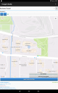
Foragers Buddy एंड्रॉइड स्मार्टफोन और टैबलेट के लिए एक मुफ्त एप्लिकेशन है, जिसे उपयोगकर्ताओं को मानचित्र पर सभी उल्लेखनीय स्थानों को चिह्नित करने में मदद करने के लिए डिज़ाइन किया गया है, जहां वे विभिन्न प्रकार के जंगली खाद्य संसाधन (डिवाइस के जीपीएस मॉड्यूल का उपयोग करके) पा सकते हैं।
आप इस फोर्जिंग ऐप का उपयोग विभिन्न बाहरी गतिविधियों जैसे जंगली जड़ी-बूटियों / मशरूम इकट्ठा करने, शिकार, मछली पकड़ने, शिविर, लंबी पैदल यात्रा आदि में कर सकते हैं।
महत्वपूर्ण: Android 10+ में नई स्थान अनुमतियाँ सेटिंग हैं। फोरेजर के बडी रूट रिकॉर्डिंग को ठीक से काम करने के लिए आपको "सभी समय की अनुमति दें" विकल्प का चयन करना होगा (ऐप जानकारी से -> ऐप अनुमतियां -> स्थान)।
फोरेजर्स बडी क्विक रेफरेंस गाइड [पीडीएफ] - https://bit.ly/3usgDt6
Forager's Buddy Quick Tutorial 1 [वीडियो] - https://youtu.be/jWCD6dVO3II
Forager's Buddy Quick Tutorial 2 [वीडियो] - https://youtu.be/s9DHd6lT160
Forager's Buddy Quick Tutorial 3 [वीडियो] - https://youtu.be/2TmSqWIxSC0
Forager's Buddy Quick Tutorial 4 [वीडियो] - https://youtu.be/f-jYRJls89Q
Forager's Buddy Quick Tutorial 5 [वीडियो] - https://youtu.be/Ssx1a3Y-C1I
बेझिझक हमें उन परिवर्तनों के बारे में बताएं जो आप Forager's Buddy में देखना चाहेंगे।
विशेषताएं (मुफ्त संस्करण):
1. शाही और मीट्रिक प्रणाली इकाइयों के बीच चयन
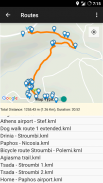
2. रूट रिकॉर्डिंग और देखना (.kml फ़ाइल स्वरूप के रूप में निर्यात मार्ग)**। आस-पास के स्थानों को देखने और .kml रूट फ़ाइलों को .gpx प्रारूप में बदलने की क्षमता है
3. सीएसवी के रूप में डेटा निर्यात और आयात करना।
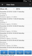
4. डेटा फ़िल्टरिंग।
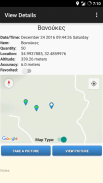
5. किसी स्थान पर फ़ोटो संलग्न करें
6. उपयोगकर्ता के वर्तमान स्थान से प्रत्येक आइटम की अनुमानित दूरी को देखना।
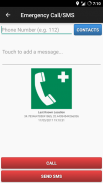
7. आपातकालीन कॉल और एसएमएस (उपयोगकर्ता के अंतिम ज्ञात स्थान और डिवाइस की बैटरी स्थिति के साथ एक एसएमएस भेजता है)।
8. पसंदीदा।
9. आइटम स्थान साझा करना (जैसे ई-मेल या एसएमएस के माध्यम से)।
10. वर्तमान स्थान साझा करना (जैसे ई-मेल या एसएमएस के माध्यम से)।
11. सीएसवी फ़ाइल साझाकरण (जैसे ई-मेल या ब्लूटूथ के माध्यम से)।
12. केएमएल रूट फाइल शेयरिंग (जैसे ई-मेल या ब्लूटूथ के जरिए)।
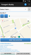
13. कस्टम स्थान। उपयोगकर्ता मानचित्र पर वांछित स्थान पर लंबे समय तक क्लिक करके, मुख्य स्क्रीन से कस्टम स्पॉट को सहेज सकते हैं।
14. हर बार उपयोगकर्ता द्वारा परिवर्तन किए जाने पर ऑटो बैकअप (.csv को निर्यात करें)।
15. डार्क थीम
16. आप आसानी से पा सकते हैं कि चालू माह में क्या चारा देना है (आपके पिछले निष्कर्षों के आधार पर)
विशेषताएं (प्रो संस्करण):
1. मुफ्त संस्करण / विज्ञापन मुक्त की सभी सुविधाएं
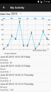
2. मेरी गतिविधि। हर महीने एकत्र की गई वस्तुओं की संख्या का चित्रमय प्रतिनिधित्व।
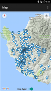
3. रडार। एक नक्शा और उपयोगकर्ता द्वारा एकत्रित वस्तुओं की एक सूची प्रदर्शित करता है। नक्शा हर 3 सेकंड में ताज़ा होता है। रडार की सीमा समायोज्य है: 0 - 1000 मीटर।
4. कस्टम स्थान। उपयोगकर्ता मानचित्र पर वांछित स्थान पर लंबे समय तक क्लिक करके कस्टम स्पॉट को "मानचित्र देखें" स्क्रीन से सहेज सकते हैं।
5. वर्तमान और सहेजे गए आइटम स्थान के लिए वर्तमान मौसम की स्थिति।
6. डेटा को .kml फ़ाइल स्वरूप में निर्यात करें (Google मेरे मानचित्र जैसे टूल का उपयोग करने वाले उपयोगकर्ता अपनी वेबसाइट या ब्लॉग के लिए कस्टम मानचित्र बनाने के लिए इस सुविधा का उपयोग कर सकते हैं)।**
7. डेटा को .gpx फ़ाइल स्वरूप में निर्यात करें।
8. नोट्स खोजें।
9. कैलेंडर में रिमाइंडर बनाएं।
10. आस-पास के स्पॉट दिखाएं (आइटम विवरण दिखाएं स्क्रीन में)।
Foragers Buddy (.csv, .gpx और .kml) द्वारा निर्यात की गई फ़ाइलें, आगे के भौगोलिक डेटा विश्लेषण के लिए GIS (भौगोलिक सूचना प्रणाली) सॉफ़्टवेयर (जैसे QGIS) में आसानी से आयात की जा सकती हैं।
अनुमतियां:
1. संपर्क/फोन - "आपातकालीन कॉल/एसएमएस" सुविधा के लिए। उपयोगकर्ता किसी आपात स्थिति में कॉल करने या एसएमएस भेजने के लिए संपर्क का चयन कर सकते हैं (यह उपयोगकर्ता के अंतिम ज्ञात स्थान और डिवाइस की बैटरी स्थिति भी भेजता है)
2. स्थान - स्पष्ट कारणों से :)
3. संग्रहण - निर्यात की गई फ़ाइलों को संग्रहीत करने के लिए जैसे: स्पॉट (.kml, .csv), मार्ग (.kml) और फ़ोटो
आप ब्लॉगर हैं या पत्रकार? Forager's Buddy PRO संस्करण का परीक्षण करने के लिए Google Play प्रोमो कोड का अनुरोध करें! https://goo.gl/ufpt7M
** KML एक फ़ाइल स्वरूप है जिसका उपयोग Google धरती, Google मानचित्र, और मोबाइल के लिए Google मानचित्र जैसे पृथ्वी ब्राउज़र में भौगोलिक डेटा प्रदर्शित करने के लिए किया जाता है।
Forager's Buddy - GPS foraging - Version 3.8.2
(02-08-2024)Forager's Buddy - GPS foraging - एपीके जानकारी
एपीके संस्करण: 3.8.2पैकेज: com.gh_its.foragersbuddyLatest Version of Forager's Buddy - GPS foraging
अन्य संस्करण


Apps in the same category


